
What it really means to surrender an aggregate licence or permit in Ontario: follow a site’s life cycle on the TOARC website
by: Carly Holmstead
It’s an age-old question: what happens to a pit or quarry once extraction has been completed and the licence or permit is surrendered? It is hard to believe that thousands of sites have been surrendered and that communities often never know they were once home to an aggregate extraction site.
By definition, surrendered aggregate licensed and permitted sites are sites where extraction has been completed, where rehabilitation has taken place per the site plan, and where the licence/permit has been relinquished by the licencee/permittee to the Ministry of Natural Resources and Forestry (MNRF).
So, back to the question. What happens to a pit or quarry once the licence is surrendered? Pits and quarries are a temporary land use, so before the licence is surrendered to the MNRF final rehabilitation is completed.
REHABILITATION: IT’S THE LAW!
The rehabilitation of pits and quarries is an important step in the sustainable management of aggregate resources in the province. In fact, to have a licence/permit for extraction, producers must have a formal rehabilitation plan fully in place. Consultation with the public, conservation authorities, municipalities, Indigenous communities and the MNRF all contribute to determining the land use after extraction.
This use could be wetlands, agricultural fields, natural areas, parks or waterbodies. “Proper rehabilitation helps to transition from a land-use of aggregate extraction to other productive land-use activities, which reduces land-use conflict and addresses social, economic and environmental concerns,” say Danielle Solondz, program manager for The Ontario Aggregate Resources Corporation (TOARC). R
ehabilitation looks different at each site and really depends on what the surrounding land is used for. “When rehabilitation is done correctly, to the naked eye you would never know it was once an aggregate extraction site, and that is really the ultimate goal,” says Solondz.
Exceptional rehabilitation practices exist and are often applied, but they can go unnoticed and unappreciated by the public due to a lack of information. The Surrendered Sites Reporting and Mapping Tool (eSurrender), located through TOARC’s website, allows community members to see a surrendered site, photos of the rehabilitated land, and a breakdown of the land use – all in one place. “The public can use the tool to better grasp what the end use of the site will look like,” says Solondz. “It is often hard to imagine how an open aggregate site will blend in with surrounding landscape when rehabilitation is completed.”
eSurrender allows for a more transparent process and better knowledge of the types of rehabilitation that can be completed. Some people may even be surprised to find that their favourite park was once an aggregate site that helped build their community, Solondz explains.
ESURRENDER: LOCATING SITES
eSurrender is an electronic database of surrendered aggregate licences and permits in the province of Ontario. Developed by TOARC in response to the 2013 Review of the Aggregate Resources Act by the Standing Committee of General Government, it provides information on the end-use of restored aggregate sites.
The tool helps bridge communication and informational gaps between the aggregate industry and the public by communicating the end-use/rehabilitation of pits and quarries across Ontario. It uses Google Earth, so users can locate all surrendered sites within the TOARC database by simply scrolling through the map.
The tool allows users to explore siteby-site and details the surrendered licence or permit number, the date surrendered, the status, operation type, licensed/ permitted area, locational information, current and surrounding land uses, as well as a photographic record. The Surrendered Sites Reporting and Mapping Tool provides a more complete understanding of the end-use of former pits and quarries.
BREAK IT DOWN: SURRENDERED PIT
When a site is surrendered, TOARC is notified, and staff create a file in the surrendered site database. During the field season, staff will inventory the site to categorize what the end use is (at the time of the visit), review satellite imagery to review surrounding land use types, and take a photographic record. All information is stored in a central database and a curated version is uploaded to the eSurrender reporting tool on TOARC’s website while protecting the privacy of the individual landowners.
Each site is identified on a map with a red pin, and once a user clicks on a pin, the below information will populate.
WHAT YOU’LL SEE:
Date Licenced/Permitted: Unknown
Date Surrendered: 2010-11-24
TOARC Status: Surrendered Operation
Type: Pit Licence
Type: Class A Licence Licenced Area (ha): 14.77
TOARC Site Visit Status: Visited
County: Halton
Township: Nassagaweya
Lot: Pt. 1 & 2 Concession: VII
Licence Location: Known
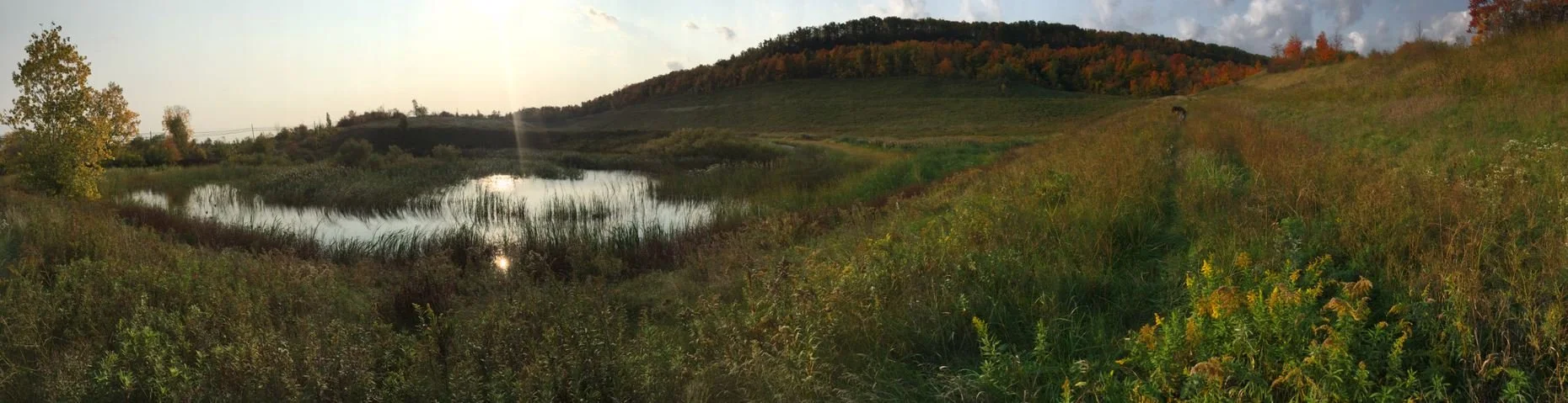
Current Land Usage (2017): Natural - Meadow/Grassland/Prairie: 80% Water - Wetland: 20%
Surrounding Land Usage (2017): Recreational: 40% Natural: 35% Agriculture: 20% Multiple: 5%
While this tool is an excellent way to provide transparency to the community, it is also important to note that this is just a snapshot in time. Some sites may have been rehabilitated as per the site plan, but the land use may have changed over time. This tool provides a more transparent process for the community and gives members an opportunity to see firsthand what the end use of a site looks like. Take a moment to explore the website and maybe even do a tour around your community to explore in-person a former pit or quarry!